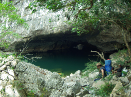
The underground Xe Bang Fai


Tham Koun Xe, the giant river cave

In the south-east of Khammouane, the existence of the underground course of another large river, the Xe Bang Fai, was known by the members of the Pavie mission. But it had little interest because, upstream to its emergence, the river was not navigable and did not give an easy access to Vietnam through the annamitic mountain range.
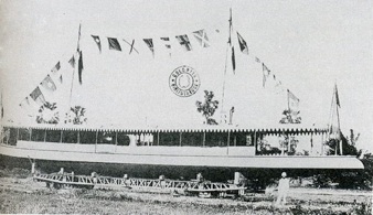
In 1904 a first scouting trip is decided. Aboard the La Grandière, a gunboat in charge of the security along the Mekong, Paul Macey takes advantage of the high waters during the rain season to go upstream the Xe Bang Fai until the huge entrance of the cave.
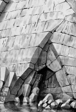
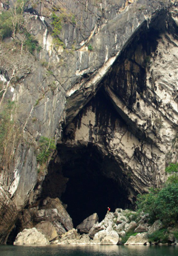
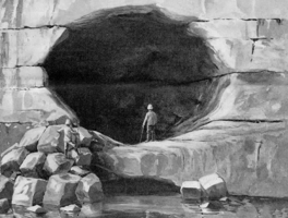
The huge downstream entrance of the Xe Bang Fai cave - This engraving by Lucien Rudaux, after Paul Macey description, gives a proper image of the actual scenery. On the right, the picture scale is given by the caver with a red backpack (©Ghommidh-2007)
The mountain and waters Spirits will never forgive the La Grandière offences and the gunship will have a tragic destiny in July 1910, sinking to the bottom of the Mekong, engulfing the cursed treasure of the kings of Luang Prabang.
In 1905, a new attempt is decided, in March, at low waters, to minimize flood risks. For the exploration, a small bamboo raft is prepared. In anticipation of possible portages, it is prefered to a small canoe.
Equipped with resinous torches, oil lamps, rattan ropes, poles, food for several days, a team of intrepid explorers launches an assault on the underground river on March 30, 1905 at 8 in the morning.

Download the whole story by Paul Macey
The Xe Bang Fai sink, as imagined by Lucien Rudaux, from Paul Macey description. This time, the ressemblance is tiny : there is no track of the stone bridge
Despite their extraordinary nature, Cupet and Macey’s explorations will be quickly forgotten. Forty years later, Henri Cassan rediscovers the extraordinary karst of Khammouane. There, he explores a splendid underground river, that he believes to be the longest in Indochina. His story is directly related to ours...
In August 1904, the "Lagrandière”, a steamboat of the Laos flotilla, went upstream of the Se Bang Faï, over a distance of 250 kilometers, up to the opening of the cave.
Arrived as far as the steam navigation could allow during high waters, gun shots were aimed at the entrance of the underground passage, while the siren of the "Lagrandière" mooed desperately. The din produced by the gun and the siren brought repercussions of echoes, unheard before. This marked our intention to steal its secrets from the Thame Nam Sé, concealed for so long by the mountain and waters Spirits.
Macey P., 1908. Cours d’eaux souterrains du Cammon au Laos. Spelunca, Bulletin et mémoires de la Société de Spéléologie, VII, 52.


The Lagrandière transportation during the Khône falls crossing
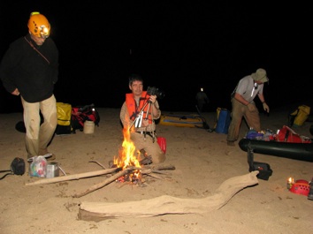
One century after Macey, the underground fire camp, in a 150 m wide galery, remain a great adventure memory
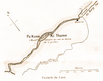
Paul Macey’s exploration sketch. He thought the length of the underground river was 4200 mètres. The actual length is 6400 m.
March 30, 1905
9 a.m. - The tunnel widens to 100 meters and the ceiling rises over 30 meters, as judged by the difficulty we have to sight it with the imperfect light that is available ! A twin car headlamp would be useful with one being focussed to the top and the other horizontally!
Several vangs [reaches in Lao] crossed, filled with water, over a width of 40 meters and a depth of 4 meters.
10 am - After a tightening of the walls we cross the seventh vang.
A white waters passage, 120 meters long, forced us to dismantle the raft and transport its parts upstream, walking on a bench of rock with saillies and sharp edges.
Noon - After reassembling the raft we start again and cross the eighth vang, in still water, 6 meters deep. The tunnel widens to 60 meters. In the middle of the river stands a limestone rock which rises 8 meters above the water level.
Lunch and first rest on a narrow stone bench.
5 p.m.- running again
The passage narrows to less than 30 meters. The water depth is 4 meters, with a rapîd flow difficult to overcome with the raft. Then there is a real choke, over a length of 40 meters. There, due to the strength of the stream, we can only progress with the help of poles and hands hooked to the rough walls. Heads of threatening rocks can be seen under the creepy waters.
We have to progress with great caution, probing constantly the river, to avoid any accident: raft breakage, loss of light, of food, and above all, fall into the water which would be fatal. The rocks hiding under the surface have the special cleavage shapes of limestone and their edges, with thin corners are as sharp as blades.
Time has been running, it’s 9 p.m., and we are getting tired.
[...]
31 Mars 1905 - 2 ½ hours a.m.. [...] Everyone is exhausted, blood flowing from many scrapes, and, despite the fear of a possible flood, we decide to take some food, and to rest for a few hours, around a large fire, thanks to a dead tree trunk, which brightness shows us the passage in all its glory!
Yes! but it is quite long!
[...]
3 pm - We are at the end of the trip, the fatigues and dangers are forgotten. The scratches, we are all covered, become less stinging; we forgive the rocks that caused our bruises.
The journey that ends here measures approximately 4200 meters. It took twenty-one hours of actual walking; ie slow, painful, with many dangers!
Paul Macey, 1908. Cours d’eaux souterrains du Cammon au Laos. Spelunca, Bulletin et mémoires de la Société de Spéléologie, VII, 52.
The crossing of the Hin Boun river cave - 1890
The “Marie Cassan” exploration - 1948
The modern era - 1991-...